▲ 김해시 국·공유재산 관리 혁신 이끈다...‘드론 도입 |
[브레이크뉴스=양영석 기자] 김해시가 첨단 드론 기술과 지적 행정의 전문성을 결합해 국·공유재산 관리의 패러다임을 바꾼다.
시는 이달부터 드론을 활용한 국·공유재산 현장조사 전면 시행을 예고하며 스마트 건설행정의 선두주자로 나섰다.
시는 단순히 장비를 도입하는 수준을 넘어, 행정의 신뢰도와 전문성을 극대화하기 위해 오랜 기간 치밀한 준비 과정을 거쳤다.
건설과에서 국·공유재산 업무를 보조하는 실무관이 작년 말 드론 자격증 중 최고 등급인 ‘초경량비행장치 조종자 1급’을 취득하며 기술적 전문성을 확보했다.
또한 지적기사 자격을 갖춘 지적직 공무원과 실무에 능한 행정직 공무원을 전담 배치하고, 촬영 영상을 정밀 지도로 변환하는 ‘드론 매핑 교육’ 및 실무 특화 교육을 이수하는 등 인적 역량을 강화했다.
현재 도내 일부 지자체에서 드론을 행정에 활용하고 있으나, 이처럼 고도의 자격을 갖춘 인력과 지적 전문가가 협업하여 매핑(mapping) 기술을 실무 전반에 전면 도입한 사례는 이례적이다.
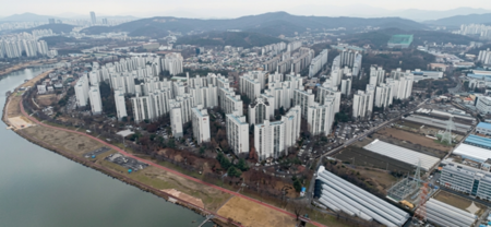
시는 건설과 소관 국·공유재산 2만 3,774필지를 대상으로 드론 촬영과 매핑 기술을 활용해 고해상도 정사영상을 제작하고 지적도를 중첩 대조함으로써, 산간 험지나 대규모 토지의 무단점유 현황을 “cm” 단위까지 정밀하게 파악할 수 있다.
이를 통해 오픈소스 지리정보시스템(QGIS) 기반의 과학적 면적 산출로 변상금 부과 및 사용허가 업무의 객관성을 확보하고, 모든 조사 자료를 시계열 데이터로 축적해 향후 발생할 수 있는 토지 경계 분쟁에도 선제적으로 대응할 방침이다.
박명준 건설과장은 “시민들이 신뢰할 수 있는 정확하고 효율적인 국·공유재산 관리를 위해 부서 직원들이 드론 1급 자격을 취득하고 매핑 교육을 이수하는 등 전문성 확보에 매진했다”며, “전문 인력의 역량을 극대화해 전국적인 스마트 행정 모델이 될 수 있도록 최선을 다하겠다”고 밝혔다.
*아래는 위 기사를 '구글 번역'으로 번역한 영문 기사의 [전문]입니다. '구글번역'은 이해도 높이기를 위해 노력하고 있습니다. 영문 번역에 오류가 있을 수 있음을 전제로 합니다. *The following is [the full text] of the English article translated by 'Google Translate'. 'Google Translate' is working hard to improve understanding. It is assumed that there may be errors in the English translation.
Gimhae City Leads Innovation in National and Public Property Management... 'Drone Introduction and Cadastral Experts'
Full Implementation of Drone Field Surveys Completely Overcomes Limitations of Human-Centered Inspections
Gimhae City is transforming the management paradigm of national and public property by combining cutting-edge drone technology with the expertise of cadastral administration.
The city announced the full implementation of drone-based field surveys of national and public property starting this month, establishing itself as a leader in smart construction administration.
More than simply introducing the equipment, the city underwent meticulous preparations to maximize administrative reliability and expertise.
A working-level official in the Construction Division, who assists with national and public property operations, earned the highest drone certification, "Ultralight Aircraft Pilot Level 1," at the end of last year, further strengthening his technical expertise.
Furthermore, dedicated cadastral civil servants with cadastral engineer qualifications and administrative staff with practical experience have been assigned to the project. Furthermore, the city has strengthened its human resources by completing "drone mapping training," which converts captured images into detailed maps, and specialized training in practical matters.
While some local governments in the province are currently utilizing drones for administrative purposes, the widespread adoption of mapping technology across the province, through collaboration between highly qualified personnel and land survey experts, is unprecedented.
Using drone photography and mapping technology, the city will produce high-resolution orthophotos of 23,774 national and public properties under the Construction Division. This will be overlaid with cadastral maps, enabling precise, centimeter-level identification of unauthorized occupations in mountainous areas and large-scale land.
Through this, the city plans to ensure objectivity in compensation assessments and permit issuance through scientific area calculations based on the open-source Geographic Information System (QGIS). Furthermore, by accumulating all survey data into time-series data, it will be able to proactively address potential land boundary disputes in the future.
Park Myeong-jun, head of the construction division, said, “In order to manage national and public property accurately and efficiently that citizens can trust, our department employees have dedicated themselves to securing expertise, such as obtaining Level 1 drone qualifications and completing mapping training,” and added, “We will do our best to maximize the capabilities of our professional workforce so that we can become a nationwide model for smart administration.”
원본 기사 보기:브레이크뉴스경남