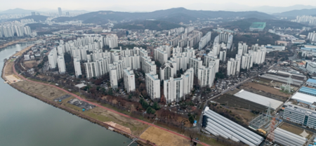
▲ 아이맵 3D 서비스 화면(사진제공:인천시) © 박상도 기자 |
(브레이크뉴스인천 박상도기자) 인천시가 20일, 시민들이 도시 공간을 보다 직관적으로 이해하고 다양한 생활 정보를 쉽게 확인할 수 있도록 인천 대표 지도포털 ‘아이맵(imap)’에 3차원(3D) 지도 서비스를 오는 23일부터 새롭게 제공한다고 밝혔다.
이번 서비스는 드론 촬영 영상을 기반으로 구축된 실사형 3차원 입체지도를 활용해 도시의 지형과 건물 외관을 실제와 유사하게 구현한 것이 특징이다.
기존의 평면 중심 지도에서 벗어나 건물과 지형을 입체적으로 표현해 시민들이 도시 공간을 더 생동감 있게 확인할 수 있다.
특히 실제 촬영 이미지를 기반으로 지형과 건물 외벽을 정교하게 재현한 3차원 입체모델을 적용해 기존 단순 블록 형태의 건물 모델보다 현실감 있는 도시 모습을 제공한다.
이를 통해 시민들은 인천의 도시 공간을 다양한 각도에서 살펴볼 수 있으며, 도시 구조와 변화 모습을 직관적으로 이해할 수 있다.
아이맵은 인천의 대표적인 지도포털 서비스로 2011년 3월 25일부터 항공사진과 위성영상 바탕 위에 토지대장, 지적도, 용도지역, 개발계획 등 모든 부동산정보를 한눈에 볼 수 있는 인천부동산광장으로 시작하였다.
새로운 아이맵에서는 기존의 2차원 지도 서비스와 함께 시민 생활과 밀접한 다양한 3차원 정책지도 약 30여 종도 제공한다.
대표적으로 인천의 육아 정책과 육아에 도움 되는 시설·장소를 지도에서 한눈에 확인할 수 있는 ‘아이플러스 지도드림’, 인천의 최초·최고 기록을 소개하는 ‘인천 최초·최고’, 우수 건축물을 소개하는 ‘인천 건축상 수상작’, 드론 촬영 영상을 통해 인천의 주요 명소와 도시 전경을 감상할 수 있는 ‘스카이 드론 인천’, 인천을 즐기는 다양한 방법을 소개하는 인천투어 누리집과 연계한 ‘인천투어지도’등 다양한 주제의 정책지도가 서비스된다.
인천시는 이번 3차원 지도 서비스 도입을 통해 도시, 육아, 관광 정보 등 행정 분야에서 공간정보 활용도를 높이고 시민들에게 실생활 중심의 지도 서비스를 확대할 계획이다.
또한, 다양한 정책지도를 통해 시민들이 인천의 공간 정보를 쉽고 편리하게 활용할 수 있도록 지속적으로 서비스를 고도화할 방침이다.
이원주 시 도시계획국장은 “아이맵 3차원 서비스는 기존 평면 중심의 지도에서 한 단계 발전한 실감형 공간정보 서비스”라며 “앞으로도 시민들이 도시를 보다 쉽고 편리하게 이해하고 활용할 수 있도록 다양한 공간정보 서비스와 정책지도를 지속적으로 확대해 나가겠다”고 말했다.
*아래는 위 기사를 ‘구글 번역’으로 번역한 영문 기사의 [전문]입니다.‘구글번역’은 이해도 높이기를 노력하고 있습니다. 영문 번역에 오류가 있을 수 있음을 전제로 합니다.<*The following is the [full text] of the English version of the article above, translated using 'Google Translate'. 'Google Translate' strives to improve comprehension. It is assumed that there may be errors in the English translation.>
3D Map Service to be Provided on Incheon’s ‘iMAP’ Starting the 23rd
Approximately 30 Types of Policy Maps on Urban Planning, Childcare, Tourism, etc. Also Provided
-Break News Incheon Park Sang-do Reporter
On the 20th, Incheon City announced that it will newly provide a 3D map service on ‘iMAP,’ Incheon’s representative map portal, starting on the 23rd, to allow citizens to understand urban spaces more intuitively and easily check various lifestyle information.
This service is characterized by its realistic 3D maps built based on drone footage, which render the city's topography and building exteriors in a manner similar to reality.
Breaking away from existing flat-centric maps, the service expresses buildings and terrain in three dimensions, allowing citizens to view urban spaces more vividly.
In particular, by applying 3D models that precisely reproduce terrain and building exteriors based on actual footage, it provides a more realistic view of the city than existing simple block-shaped building models.
Through this, citizens can examine Incheon's urban spaces from various angles and intuitively understand the city's structure and changes.
iMap is Incheon's representative map portal service. It began on March 25, 2011, as the Incheon Real Estate Plaza, where users could view all real estate information—including land registers, cadastral maps, zoning classifications, and development plans—at a glance, all set against a backdrop of aerial photographs and satellite imagery.
Along with the existing 2D map service, the new iMap also provides approximately 30 types of diverse 3D policy maps closely related to citizens' daily lives.
Notably, policy maps covering various themes are being provided, including ‘i-Plus Map Dream,’ which allows users to view Incheon’s childcare policies and helpful facilities and locations at a glance; ‘Incheon First & Best,’ which introduces Incheon’s firsts and best records; ‘Incheon Architecture Award Winners,’ which showcases outstanding architecture; ‘Sky Drone Incheon,’ which allows users to appreciate major landmarks and cityscapes through drone footage; and ‘Incheon Tour Map,’ which is linked to the Incheon Tour website to introduce various ways to enjoy the city.
Through the introduction of this 3D map service, Incheon City plans to enhance the utilization of spatial information in administrative fields such as urban planning, childcare, and tourism, and to expand map services focused on daily life for citizens.
Furthermore, the city intends to continuously upgrade its services to ensure that citizens can easily and conveniently utilize Incheon’s spatial information through these diverse policy maps.
Lee Won-ju, Director of the City Planning Bureau, said, “The iMap 3D service is an immersive spatial information service that has advanced one step beyond existing flat-screen maps,” adding, “We will continue to expand various spatial information services and policy maps so that citizens can understand and utilize the city more easily and conveniently.”
원본 기사 보기:ebreaknews.com