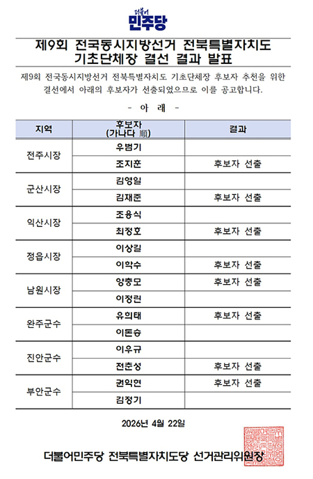
▲ 합천군 전 지역 연속지적도 |
[브레이크뉴스=강동호 기자] 합천군은 2개년에 걸쳐 추진해 온 '연속지적도 정비사업'결과를 13일 부동산종합공부시스템에 최종 탑재한다고 밝혔다.
군민들에게 정확하고 신뢰성 있는 토지 정보를 제공하기 위해 2024년 국토교통부 시범군으로 선정된 연속지적도는 지적도와 임야도를 디지털화해 전국 단위로 하나로 연결한 전자 도면이다.
이는 토지이용규제 안내나 각종 도시계획 수립, 국공유지 관리 등 현대 토지 행정의 기초 자료로 활용되고 있다.
이번 탑재 대상은 합천군 전체 17개 읍 면의 32만여 필지이며 특히 효율적인 협업 행정을 위해 도시개발허가과의 연속주제도도 동시에 탑재해 공간정보의 정확도를 획기적으로 높일 계획이다.
군은 이번 정비를 통해 그간 누적된 토지이동 미반영 사항과 경계 오류를 해소해 토지 행정의 신뢰성과 정확성을 향상하고 공간정보 기반의 고품질 서비스를 제공할 수 있을 것으로 기대하고 있다.
김외숙 민원지적과장은 "정확한 연속지적도는 스마트 행정의 뿌리이고 성공적인 시스템 탑재를 통해 군민들에게 신뢰받는 지적 서비스를 제공하고 재산권 보호에 앞장서겠다"고 밝혔다.
*아래는 위 기사를 '구글 번역'으로 번역한 영문 기사의 [전문]입니다. '구글번역'은 이해도 높이기를 위해 노력하고 있습니다. 영문 번역에 오류가 있을 수 있음을 전제로 합니다.<*The following is [the full text] of the English article translated by 'Google Translate'. 'Google Translate' is working hard to improve understanding. It is assumed that there may be errors in the English translation.>
Hapcheon County Completes Digital Land Cadastral System with Continuous Land Cadastral Map Improvement
Hapcheon County announced on the 13th that the results of its two-year "Continuous Land Cadastral Map Improvement Project" will be finalized and integrated into its Real Estate Comprehensive Study System.
Selected as a pilot county by the Ministry of Land, Infrastructure and Transport in 2024 to provide accurate and reliable land information to residents, the Continuous Land Cadastral Map is a digital map that connects cadastral and forestry maps nationwide into a single, unified, electronic map.
This map serves as the foundation for modern land administration, including land use regulation guidance, various urban planning, and national and public land management.
This update covers approximately 320,000 parcels of land across 17 townships and townships in Hapcheon County. To facilitate efficient and collaborative administration, the Continuous Land Cadastral Map from the Urban Development Permit Division will also be integrated, dramatically improving the accuracy of spatial information.
The county expects this update will address accumulated issues of land transfer failures and boundary errors, thereby enhancing the reliability and accuracy of land administration and providing high-quality services based on spatial information. Kim Oe-sook, Director of the Civil Affairs and Land Registration Division, stated, "An accurate, continuous land registration map is the foundation of smart administration. Through successful implementation of this system, we will provide trustworthy land registration services to the public and take the lead in protecting property rights."
원본 기사 보기:브레이크뉴스경남