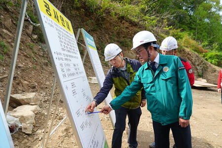
▲ GIS 기반 CCTV 열람시스템 도입한 재난상황실 모습(사진제공=양주시청) © 브레이크뉴스 하인규 기자 |
 ▲ 강수현(좌측 6번째) 양주시장 GIS 기반 CCTV 열람시스템 도입 재난상황실 방문 기념촬영 모습(사진제공=양주시청) © 브레이크뉴스 하인규 기자 |
(양주=브레이크뉴스 경기동북부)하인규 기자=양주시가 ‘GIS(지리정보시스템) 기반 CCTV 열람시스템’을 재난상황실에 도입하고 이를 전 직원을 대상으로 개방해 신속하고 효율적인 행정업무를 지원한다고 밝혔다.
이번 시스템 도입은 민원 대응 및 재난 상황 확인 시 공무원이 직접 현장을 방문해야 했던 기존 업무 수행 방식의 한계를 극복하고 CCTV를 활용해 사무실에서도 실시간으로 현장을 확인할 수 있도록 설계됐다.
시는 관내 설치된 5,000여 대의 CCTV를 GIS 지도 위에서 위치 기반으로 선택·열람할 수 있도록 시스템을 도입했으며 재난상황실 내에는 모니터링 단말기 16대를 신규 설치해 재난 상황과 무관한 일반 행정업무에도 즉각 활용할 수 있도록 했다.
특히, 이 시스템은 모든 직원에게 개방되어 평상시에도 ▲민원 현장 확인, ▲시설물 점검, ▲환경 관리 등 다양한 행정 업무에 광범위하게 활용할 수 있다.
이를 통해 행정 처리 속도는 물론 출장비 등 예산 절감 효과도 기대되고 있다.
시 관계자는 “이번 GIS 기반 CCTV 시스템 도입으로 공무원 누구나 즉시 현장을 확인하고 민원에 대응할 수 있게 됐다”며 “시민이 체감할 수 있는 신속하고 정확한 행정 서비스를 제공하는 데 큰 도움이 될 것으로 기대한다”고 말했다.
이어, “앞으로도 스마트 기술을 적극 도입해 시민 중심의 선제적이고 효율적인 행정을 실현해 나가겠다”고 밝혔다.
하인규 기자 popupnews24@naver.com
아래는 위의 글을 구글번역이 번역한 영문의 전문이다. '구글번역'은 이해도를 높이기를 위해 노력하고 있습니다. 영문 번역에 오류가 있을 수 있음을 전제로 합니다.Below is the full English translation of the above text translated by Google Translate. 'Google Translate' is working to improve comprehension. It is assumed that there may be errors in the English translation.
Yangju City introduces 'GIS-based CCTV viewing system'
5,000 CCTVs can be checked in real time based on maps...Expectations for rapid civil complaint processing and disaster response
Expectations for improved civil complaint processing speed and minimization of on-site visits
-Reporter Ha In-gyu
(Yangju=Break News Gyeonggi Northeast) Yangju City announced that it will introduce a 'GIS (Geographic Information System)-based CCTV viewing system' to the disaster situation room and open it to all employees to support rapid and efficient administrative work.
The introduction of this system was designed to overcome the limitations of the existing work method where civil servants had to visit the site in person to respond to civil complaints and check disaster situations, and to enable real-time on-site confirmation from the office using CCTV.
The city introduced a system that allows the selection and viewing of approximately 5,000 CCTVs installed in the city on a GIS map based on location, and 16 monitoring terminals were newly installed in the disaster situation room so that they can be used immediately for general administrative work unrelated to disaster situations.
In particular, this system is open to all employees and can be widely used for various administrative work such as ▲ checking civil complaints on-site, ▲ inspecting facilities, and ▲ managing the environment even during normal times.
Through this, not only is the speed of administrative processing expected to increase, but also the budget reduction effect such as travel expenses is expected.
A city official said, “With the introduction of this GIS-based CCTV system, any civil servant can immediately check the site and respond to civil complaints,” and “We expect it to be of great help in providing fast and accurate administrative services that citizens can feel.”
He continued, “We will continue to actively introduce smart technology to realize preemptive and efficient administration centered on citizens.”
원본 기사 보기:브레이크뉴스 경기동북부