|
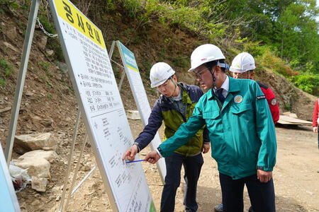
(포천=브레이크뉴스 경기동북부)하인규 기자=포천시(시장 백영현)는 지난 21일 시정회의실에서 공간정보 전문 기관인 공간정보품질관리원과 ‘공간정보 품질 향상을 위한 업무협약(MOU)’을 체결했다.
이번 협약은 드론 등 첨단기술을 활용한 공간정보 품질 관리와 기술 지원을 통해 행정 효율성을 높이고, 시민 중심의 스마트 행정 기반을 조성하기 위해 추진했다.
백영현 포천시장과 정형교 공간정보품질관리원장은 △첨단 이동 수단(모빌리티) 및 공간정보 분야 공동 협력 △실무 아카데미 운영 및 전문 인력 상호 교류 △드론 및 공간정보 분야 사업 공동 추진 △특구 및 협력 단지(클러스터) 조성에 대한 공동 협력 등이 주요 내용인 협약서에 서명했다.
양 기관은 이번 협약을 시작으로 포천시의 기술 기반을 고도화하고 디지털 기반의 지속 가능한 도시행정을 실현할 계획이다.
백영현 포천시장은 “정확하고 신뢰할 수 있는 공간정보는 도시계획, 재난 대응, 대민 서비스 등 행정 업무를 실현하는 데 있어 핵심 기반”이라며, “이번 협약을 계기로 공간정보 분야와 드론 산업의 융합을 이뤄 더욱 정교하고 효율적인 행정을 실현하겠다”라고 말했다.
한편, 공간정보품질관리원은 국토교통부 산하 공간정보 품질 전문 공공기관으로, 데이터 품질 검수, 기술 자문, 연구개발 등을 통해 공공기관과 민간기업의 공간정보 활용을 지원하고 있다.
하인규 기자 popupnews24@naver.com
아래는 위의 글을 구글번역이 번역한 영문의 전문이다. '구글번역'은 이해도를 높이기를 위해 노력하고 있습니다. 영문 번역에 오류가 있을 수 있음을 전제로 합니다.Below is the full English translation of the above text by Google Translate. 'Google Translate' is working to improve comprehension. It is assumed that there may be errors in the English translation.
Pocheon City, Signing Business Agreement to Improve Spatial Information Quality Using Drones
Together with the Spatial Information Quality Management Institute
- Reporter Ha In-gyu
(Pocheon=Break News Gyeonggi Northeast) Pocheon City (Mayor Baek Yeong-hyeon) signed a 'Business Agreement (MOU) to Improve Spatial Information Quality' with the Spatial Information Quality Management Institute, a specialized spatial information organization, at the city council meeting room on the 21st.
This agreement was promoted to improve administrative efficiency through spatial information quality management and technical support using cutting-edge technologies such as drones and to create a smart administrative foundation centered on citizens.
Mayor Baek Young-hyun of Pocheon City and Director Jeong Hyeong-gyo of the Spatial Information Quality Management Institute signed an agreement with the main contents of △joint cooperation in the fields of advanced transportation (mobility) and spatial information, △operation of a practical academy and mutual exchange of professional personnel, △joint promotion of drone and spatial information projects, and △joint cooperation in the creation of special zones and cooperative complexes (clusters).
Starting with this agreement, the two organizations plan to advance Pocheon City’s technological foundation and realize sustainable digital-based urban administration.
Mayor Baek Young-hyun of Pocheon City said, “Accurate and reliable spatial information is the core foundation for realizing administrative tasks such as urban planning, disaster response, and public services,” and added, “With this agreement as an opportunity, we will realize more sophisticated and efficient administration by converging the spatial information field and the drone industry.”
Meanwhile, the Spatial Information Quality Management Institute is a public institution specializing in spatial information quality under the Ministry of Land, Infrastructure and Transport, and supports the use of spatial information by public institutions and private companies through data quality inspection, technical consulting, and research and development.
원본 기사 보기:브레이크뉴스 경기동북부